Rising sea levels could topple the proud status of some British mountains, reducing them to the status of mere hills. Those in greatest danger of demotion include a peak in the Yorkshire Dales that was only reclassified as a mountain a few weeks ago.
The Ordnance Survey (OS) uses mean sea level as the starting point for measuring the absolute height of mountains, which must be a at least 609.6 metres (2,000ft) above sea level – but several peaks in England, Scotland and Wales are only a few centimetres taller than that.
Mean sea level, the halfway mark between high and low tides, is measured by a gauge at Newlyn in Cornwall. But the point used by the OS was established almost a century ago, and since then sea levels have risen and are continuing to rise at an accelerating rate, mainly through climate change.
“We have to measure from a fixed point, and there are no immediate proposals for a change, but rising sea levels could obviously be a factor if there is a change in the future,” an OS spokesman said. “Clearly if the fixed point was taken from a higher level, the heights measured would drop by the same amount, and that certainly could affect many hills and mountains.”
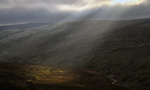
Thack Moor in Cumbria, which was only recently reclassified as a mountain. Photograph: Andy Sutton/Alamy Stock Photo
Calf Top in the Yorkshire Dales only achieved mountain status in September, after the OS determined its true height is a few centimetres taller than was concluded when it was last measured in 2010, putting it just over the required height for a mountain. Any change in the base point would knock it back down again.
Myrddyn Phillips is an amateur surveyor who worked on Calf Top with Hill Data and Mountain Surveys, one of several amateur groups whose hours of unpaid work, out on the slopes in all weathers, has produced new data that has been accepted by the authorities.
Thack Moor in Cumbria also recently became a mountain through Phillips’s work with John Barnard and Graham Jackson, of G&J Surveys. Their measurements, repeated at the request of the OS, confirmed its true height was just 2cm over the 609.6-metre qualifier.
Phillips was enthusiastic about the possibility of change: “That would be fantastic, on the whole I like change.
“It will be incredibly interesting if Ordnance Survey change their datum point as this will affect all known heights throughout Britain, and even if this change equates to only 40-45cm it will affect a multitude of hill and mountain classifications,” he said.
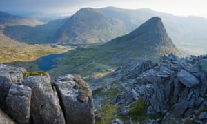
Looking towards Tryfan in Snowdonia national park, north Wales. The hill is part of the Nuttall group of hills. Photograph: Alamy Stock Photo
A change could affect the status of many sites cherished by walkers who like to tackle all the mountains in a group, including the Munros in Scotland, which are all over 914 metres (3,000ft), the slightly less challenging 762-metre (2,500ft) Corbetts, and the Hewitts, Nuttalls and Deweys in England and Wales.
https://www.theguardian.com/uk-news/2016/oct/09/rising-sea-levels-reduce-several-uk-mountains-hills-ordnance-survey
http://tidesandcurrents.noaa.gov/sltrends/global_50yr.htm?stnid=170-161
Over the whole period, the rate of rise has been 1.76mm/year, of which approximately half is due to the land sinking.
Newlyn is in Cornwall, but most of Britain’s mountains, with the exception of Wales, are in Scotland and the northwest of England, where the land is actually rising.
The two particular examples used by the Guardian, Calf Top and Thack Moor are in the yellow band. The nearest tidal gauge is at Workington, on the edge of the Lake District. Here, sea levels have actually been dropping.
I realise that none of this accords with the Guardian’s world view, but, hey, if you are a Guardianista, who needs facts?


Maybe they should have read this first:
http://www.telegraph.co.uk/news/earth/earthnews/6226537/England-is-sinking-while-Scotland-rises-above-sea-levels-according-to-new-study.html
Great response Paul to what we see which is greater and greater lies from those living the life of this nonsense. I don’t know why everyone is worried about clowns – they are already here at the Guardian.
I have a grandfather clock here in Texas that I am continually adjusting the length of the pendulum in accord with the MSL at London Bridge, so that there are so many ticks and tocks per day and the chimes are in accord with the Westminster ones. I have mostly been lengthening it a tiny bit each year or so as the sea gets higher and there is more rotational mass in a day. But if the hills are shorter maybe I should not be lengthening it quite as much as the rotational mass might not be that much different. And I have an atomic radio clock inside the door that communicates with Colorado as a backup calibration. Is that really the same time as England? Now I’m wondering. The train runs by every morning about 0300 or so depending on the carloads…
So Hinkley Point C and the Swansea Bay tidal barrage aren;t going to be much use then.
It’s fortunate that nobody with any sense reads the Grauniad.
And even those with no sense aren’t buying it much judging by the losses. Probably just the BBC order keeping it afloat. They couldn’t let it die as where would their news stories come from. Remember the Cherie Blair, the con man and the dodgy flats deal? All over the front pages except for the Guardian, and not a peep on the BBC either until the Guardian finally had to admit something was going on.
Maev Kennedy is the author of the ‘Hamlyn History of Archaeology’, and as such you would think she would know better. Apparently not! Obviously taking the Gruadian’s shekel has dulled her intellect allowing her spout dystopian pseudoscience claptrap.
She sits so well on her vast contemptuously complacence green credentials that she even works for the BBC on the trendy lefty program ‘Open Book’. A program so left and PC that the mere mention of ‘Business’, ‘Industry’ or ‘Work’ are not uttered without the snarling epithets like ‘swınd|e’ ‘toil’, ‘misery’, or ‘Thatcher’ being included.
https://en.wikipedia.org/wiki/Maev_Kennedy
is berk gendered?
Follow the French example and add an ‘e’ for the feminine! Très sophistique!
Careful analysis shows that from 1992 to 2005 the sea level decreased at an average rate of about 7mm / y, with high probability. From then to 2015 – the latest data – a non-significant increase seems to have occurred. Just saying!
What is so frustratingly sad is that if we don’t believe these pseudo scientific pontificates, one is a cretin.
mmmm…. not quite as described. Although the OS maps carry the notice that heights are above MSL this is not the case in practice. The MSL at Newlyn was transferred decades ago to a series of thousands of benchmarks throughout the country which are now the basis for measuring heights. So if the MSL at Newlyn does vary this has no relevance to the accepted terrestrial heights and the mountains remain the same height as they always were. Incidently the tidal designations such as MSL, MHWS and tidal ranges etc no longer have any technical use. All hydrographic heights and depths are now referenced from LAT (lowest astronomical tide) so the transfer of heights between maps and charts is a bit of a grey area.
Sea levels are rising fast, meaning hills and mountains are “shrinking”. But a hill was recently discovered to be a few cm higher than when they “incorrectly” measured it 6 years ago, allowing it to be classified as a mountain.
Even before Paul’s corrections that seems a little odd.
About Newlyn: “Over the whole period, the rate of rise has been 1.76mm/year, of which approximately half is due to the land sinking.”
Rubbish – the GIA graphic shows Newlyn to be in a zero GIA zone. Newlyn is subsiding at 0.17 mm/year.
http://www.sonel.org/spip.php?page=gps&idStation=753.php
Are you blind?
If you disagree with the Met Office, I suggest you contact them, and not waste my time.
If you leave any more spurious comments, you’ll be banned